
For much of the six months or so before starting out on my final cross-Scotland stage, I had genuine doubt whether I would ever begin it, let alone finish.
But the NHS physios of east London seemed just about to have battered my achilles into submission, and buoyed by the confidence of the Peak District stage of my cross-England walk a month earlier, I set out with keen anticipation for Sutherland.
This is grand country, with no easy ways across unless you stick to a ribbon of tarmac. Throughout I followed a variant of the Cape Wrath Trail, itself not strictly a set route, but one of the Trail’s pleasures, as it channels the hardy further north, is the camararderie of meeting fellow walkers and hearing their tales.
This – and an extraordinary, final, visual phenomenon – was to make the transit, for me, perhaps the most memorable walking experience of my life.
Assynt
The last Munro territory of the Cape Wrath Trail is dominated by the twins of Ben More Assynt and Conival. The high pass beneath the latter gave a magnificent view over this primeval area, with hills bearing legendary names such as Quinag and Canisp.
Stage 31, Friday 30 May 2014: through Glen Oykel, 12 miles
A nice easy start along clear estate tracks, at least for the most part. Over a pint in the Oykel Bridge Hotel – a friendly place now, though once it had a more forbidding hunters-and-shooters reputation – the landlord told me much about the steady stream of walkers he sees on the Trail, including a couple already earlier that day. To reinforce the point, in came Phil, who had been at Knockdamph bothy overnight. He set off from the pub before me, but I caught him up in a couple of miles. After the main estate track finishes, there’s a reasonable path by the fishing beats of the glen.

Glen Oykel and Ben More Assynt
We found a little short cut at 318091, up to a forest track, to snip a corner on the river. Phil would be going a different way to me tomorrow, the tough route by Gorm Loch Mor, and chose a camp site just before the river confluence at 327129; I continued a little further, nearly as far as the gravel beds in the upper glen, with magnificent views all around.

My pitch in Glen Oykel
Stage 32, Saturday 31 May 2014: upper Glen Oykel to Inchnadamph, seven miles
Above my tent rose the Munro of Ben More Assynt, and beyond that its partner Conival. Despite the beautiful morning, I gave no thought to their ascent, having heard that there might be difficult ground between them. Wise decision! There is an infamous bad step just north of the 960m spot height. In the April 2021 issue of The Great Outdoors magazine, one of their regular contributors David Lintern wrote as follows:
“From the south, going up and over [the bad step] is exposed but doable; but getting off it requires a literal leap of faith, with high potential for death or injury and a long way from help … There’s a reason it’s not in any guidebooks I’ve come across – so treat it with extreme caution!”
Maybe I could have done it. Conditions were as good as they could be, but I had a full pack with several days’ food still untouched. And for a blow by blow account, you can check out Mountain Coward (!) and decide for yourself. Still, better safe etc, and with some big days to come, there was no harm in conserving a bit of energy. (I’d given no thought, alas, to climbing the Corbett of Breabag to the west of the Oykel – it’s a “wonderful” hill, says Lintern.)
And it was still a grand walk, with plenty to linger over. The ascent to the 1700ft Bealach Tralgill is slow and often trackless. It’s a great spot on the principal east-west watershed of Scotland, the two Munros behind you, the remarkable Corbetts of Canisp and the three-pointed Quinag in front.

Bealach Tralgill

Looking back to Conival
I remembered my brief ascent of one of the Quinag peaks nearly forty years before, bucking out of the other two due to a misplaced concern for the weather. The CWT guide book hypes up the descent from the bealach, but certainly in these benign conditions the initial rocky steps were none too difficult. And always, on the way down, Quinag to admire beyond.
Sea lochs and high passes
The next two days were the big days of this stage, with two high passes to be crossed, two sea lochs to be descended to, and much trackless terrain to be tackled. I’d planned for a bothy overnight, but changed my plans ‘on the ground’ to split the two days more evenly.
Stage 33, Sunday 1 June 2014: Inchnadamph to Maldie Burn, 15 miles
It’s a steep climp out of Inchnadamph, and though I took it quickly enough, there were many good reasons to keep looking backwards.

Inchnadamph, with Canisp behind
I’d expected to cover just 12 miles today, unless I picked up the Corbett of Glas Bheinn, barely 500ft above the first high pass, Bealach na h-Uidhe, itself a shade over 2000ft. I’d made a promise to myself though not to take it in anything other than perfect weather, and as I made the bealach a little light rain started to fall. The further climb didn’t look that inviting either, with a deal of scree to be faced – not my favourite walking surface. So without any guilt, I started back down, on an interesting little path that wended its way cleverly downwards, though I did feel a little guilty as I disturbed a game hen and her chicks just below the little double lochans at 279270.

The twin lochans
Eventually the path starts zig-zagging quite steeply downhill, and peters out at a burn. It’s a case then of make your own way to the valley floor, none too difficult in truth. Indeed, the valley itself is tougher – there’s a bit of a path, but it’s broken, and take care with remnants of an old wire fence. Compensation is the view of the Eas a Chual Aluinn waterfall, the highest in Britain at 658ft of drop.

The waterfall of Eas a Chual Aluinn
Reaching the sea loch of Loch Beag isn’t quite an end to the tricky stuff either, but soon I was inside Glencoul bothy for a planned break. Here two heavy-packed (25kg each!) Germans soon joined me, the weight explained when one produced a tin of spam and can opener. Credit to struggling in via Gorm Loch Mor with that on their backs.
The path now climbs 700ft above the Aird da Loch peninsula. Just above the bothy, a couple of little diggers had started ‘improvements’: the estate, perhaps, looking to run a landrover track in place of the current stalker’s path. That would be a shame, for the feet have no interest in wide paths, whereas currently there’s just the right of looking about to do, with a few cairns at the path-top to help the brain too. By now I’d determined that an extra hour beyond the bothy at Glendhu, by the eponymous sea-loch, would serve me well, and I looked out for possible camp sites: I thought I could see some.

Glendhu
At the bothy I met a Tynesider, Steve – his path and mine would cross again later, but tonight he had decided to stay at the bothy. Bowling along the broad Kyelsku track from Glendhu (sometimes it’s nice to have a broad track!) I found that most of the green I had seen earlier was bracken, but just beyond the little hydro-electricity works of Maldie Burn I found a spot that only needed a little gardening. Very midgy though, the worst of the entire trip.
Stage 34, Monday 2 June 2014: Maldie Burn to Rhiconich, 16 miles
Staying at Glendhu, this would have been a 19 mile day; from my camp, nearly three less. But as I climbed the path above the Maldie Burn up to the 1300ft pass, I realised that it was much broader than the single dashed line of the OS map – perhaps it had been converted to land-rover status for the hydro works I’d seen the night before. Certainly posts warned that 33kV cables were buried beneath/beside – better than pylons, at least.

Quinag from the Maldie burn
The path continued beyond the summit shieling, where I discovered a nearly-full 2l Sigg bottle whose loss would no doubt would have inconvenienced a recent traveller hugely, all the way to the forestry above Achfary.

Arkle from above Achfarry
Logging operations were in progress, but beyond them the track welcomingly turned softer, and little over two hours from camp, I was down at the ‘main’ A838 (single-track). The CWT alternative to a hill-route over Ben Dreavie stays on the road for a few miles, but I split off after one, to take the alternative to the alternative, by the rough ground beneath Arkle. This is one of two great Corbetts that dominate north-west Sutherland, the other being the remarkable Foinaven – followers of jump racing will know both names, the former as one of the greatest racehorses of all time, the latter perhaps the luckiest-ever Grand National winner.
From leaving the track at Lone all the way to Rhiconich, seven miles, there’s barely 100ft of rise but scarcely a track either. It took me over four hours of walking, in contrast to the three for nine hilly miles before. But my mind was engaged throughout, unlike during the morning – or perhaps partly engaged; I descended to the shore of Loch an Nighe Leathaid when I should have stayed above it, and headed for Loch a’Garbh-Bhaid Mhor at the first branch of Allt an Riabhach and not the second. Steve, who had taken the A838 alternative, caught me just before the latter loch, having found that better line.

Descending to Loch a’Garbh-bhaid Beag
We walked the remaining miles to Rhiconich together. He helpfully pointed out the adder I had nearly stepped on. Not the only danger: note that the Garbh Allt crossing requires the respect given to it in the Cicerone guide – we were pleased to have low levels, and still had to take great care.
The final push
It’s not, by any means, all over at Rhiconich, but one is entitled to feel the end is near. Thoughts turn to the practicalities of crossing the MOD range on the peninsula, a topic of conversation between walkers ever since Oykel Bridge.
My own enquiries in early May had told me ‘no bombing in June, definitely’. Phil on day one had disabused me of that, but phone calls from both Oykel Bridge and Inchnadamph only reached answerphones. Finally, I spoke to a human just before I left Rhiconich: there would be bombing on ‘my’ day, Wednesday, but it would be over by noon. Say 2pm to be on the safe side.
Stage 35, Tuesday 3 June 2014: Rhiconich to Sandwood Bay, 12 miles
A very easy day, seven miles on quiet road, five on easy track. The dreich conditions of Sunday and Monday had gone too, so this was a day for lingering.
On the way into Kinlochbervie I met three Edinburgh students walking the CWT from Ullapool as part of their degree (!) – there were more like them, they said. No sign though of Steve, or the Germans (who I’d heard had taken a bus from Kyelsku after Glendhu), or the two Frenchmen also walking north; Phil I knew was on a quicker schedule than I. At a little rise above the port I turned to scan the mountains once more, Canisp and Quinag, Conival, Ben More Assynt, and Glas Bheinn, Arkle and Foinaven: a wonderful vista, but land I was leaving.

Foinaven, Arkle and Ben Stack from the Blairmore road
The track from Blairmore, though wide, is soft and a joy to walk, with soon a tantalising short glimpse of the lighthouse-top at the Cape. Many day walkers, and even a runner, were enjoying the recreation. The walk between dunes and on the beach of Sandwood Bay in no way failed to betray my eager anticipation – it really is a gem of a setting, the better for not a single building in sight. In the Med it would be a holiday complex, renamed Sandwood Euro Resort or some such. I pitched tent and enjoyed a long paddle in the sun.

Sandwood Bay: beach

Sandwood Bay: rocks
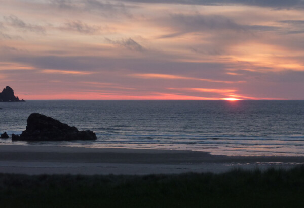
When I came back, the students – now 11 of them, mostly Americans, mid 20s to 30s I’d guess – had pitched just along from me, and we had a nice chat. Later I watched the sunset that I had dreamt about, and looked forward to the culmination tomorrow.

Sandwood Bay: sunset
Stage 36, Wednesday 4 June 2014: Sandwood Bay to Cape Wrath, eight miles (and on to Kearvaig bothy, 13 miles)
I lingered at Sandwood a while, as there was no point being too early at the bombing range boundary, but even so was to surprised to see no sign of the Americans striking camp.

Looking back to Sandwood Bay, the American camp on the left
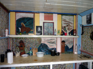
Inside Strathchailleach bothy
I lingered for a couple of hours at Strathchailleach bothy. It’s not difficult to do; once, this was the last inhabited house in Britain to be without any mains services, and the wall paintings of its then resident Sandy McRory-Smith are still extant, and it’s almost a rite of passage to walk over to the peat bank that sustained him with fuel and cut a little material for overnighters.
And so up the little rise between the bothy’s burn and the River Keisgaig. It was 2ish, and I heard the jets. A delayed last run, I thought? But over the little rise, incontrovertably, was a red flag. I run through the rehearsed options one more time: retreat, hang around, risk it; probably hang around, then retreat, and try tomorrow. But as I walked towards the fence, a spotter on the hill moved to the flag, and … TOOK IT DOWN! If he had been closer, he would have been embraced. But at the fence, I saw another flag, so I walked towards it and the spotter … and he jumped on his quad bike and TOOK THAT DOWN TOO! He watched me crossing the fence, then beetled off.
This is a full-on moorland stage, never above 500ft, but no respite from tussocky grass and bog until the track just over a mile from the lighthouse. It felt, on this breezy sunny day, an empty wildreness, particularly apposite for my last few miles across the nation of Scotland. It took for ever, it took too long, and it did not take long enough.

Moorland before the Cape
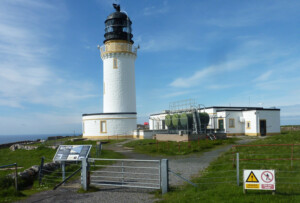
Cape Wrath lighthouse
On the track, around a couple of bends, and the lighthouse at the Cape came into view. After years of thought and effort, this is not a place to rush away from. The last tourist minibus back down to the ferry passed me just before the end, but I would not have taken it even if I could. At the Cape, I enjoyed a mug of tea, tour of the site and chat with John, owner of the café – it seems I was the day’s only finisher, despite the fine conditions.
So my walk across Scotland had ended . All that remained was to wander back along the track and drop down to the wonderful bothy at Kearvaig. It’s sited at a bay which is nearly as good as Sandwood, if not better for being a little more intimate. I clambered a little way on the rocks for a view of the puffin colony John had told me about. After dinner, I went out to see the sunset, not quite as spectacular as Sandwood, but still pretty good. The sun dipped one last time.
I went back to the bothy, had a brew, and 20 minutes later came back for the twilight colourations. Nothing prepared me for what I saw. The sun was back in the sky. How this must have spooked the ancients, or supernatural believers now. It was, I guess, some sort of refraction of the set sun through the atmosphere, or its reflection on the sea and projection onto cloud. Whatever the explanation, it was a transfixing experience for my night on the Wrath peninsula, and a fitting end to my walk across wildest Scotland.
Sunset at Kearvaig …
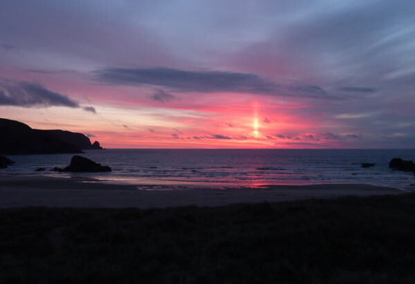
… and the second sun
Postscript: leaving the cape, Thursday 5 June 2014: Kearvaig to Durness
The weather gods paid me back for the double sunset with steady rain the next morning. It’s a short mile back up the track to the junction, where John had said wait for half an hour or so and one of the two tourist buses will pick you up. Half hour in the rain, desolate spot, nothing. What to do? Perhaps there were no tourists in the rain, perhaps no ferry either. Two choices: five miles back to Cape Wrath, or eight miles to the Keoldale ferry which links the peninsula with the mainland. I didn’t want an anti-climax. Off on the lonely miles to the ferry.
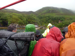
After a mile or so a truck comes up the path. It’s driven by Fiona, an MOD contractor whose job it was to take down the remaining red flags after yesterday’s exercise (including one at Kearvaig); her colleague Roberta (so wrong sex guessed yesterday) had spotted me yesterday, bless her. Fiona is happy to take me up to the Cape, and back to the ferry later if needed. Then we meet both the two minibuses going down, in short order; the first is full but the second has Steve, and another walker in green waterproofs, plus a few tourists. Within yards we meet the two Germans coming off the hill. It’s agreed that we’ll go back to the Cape and wait for them, then take them off, it being likely that there will be no other buses for a while. While waiting at the Cape I show off yesterday’s photographs – I get applause! Nobody, today, could see a thing.
On the Keoldale ferry
The Germans arrive, we set off, then the two French walkers come off the hill. It’s a repeat, the Cape a third time for me! This time it’s the last. The ferry shuttle splits us up a bit, but Steve, the two French, green waterproof man and me are together on the ‘mainland’ for the two miles to Durness.
Green waterproof man, it transpires, is none other than Peter Lincoln, fresh off 1,200 miles direct from Land’s End, and celebrated for epic walks including the first-ever continuous round of Munros, Corbetts and Grahams, nearly a year in 1997-98. This certainly put my modest plod in perspective. I’m the only one bound for the Durness bunkhouse – Peter and Steve don’t hang around, and take the afternoon bus – but there I meet the bulk of the American party, also finished today – total CWT finishers today in the rain 16, just me in the sun yesterday! No others wanted to risk the bombing; I’m so glad I had.
Accommodation

Rhiconich Hotel
Three wild camps, two B&Bs, one bunkhouse: a nice mix, I thought, especially when the first and last camps were in such wonderful spots. Not so good at Maldie Burn, but at least I found a reasonably stone- and bracken-free spot without too much searching, just beside the track and with a lovely view across Kylesku.
I’d planned to use the bunkhouse at Inchnadamph, but it was block-booked, and they put me on to The Byre, just round the corner. This is sometimes let as self-catering so it comes with fridge and breakfast essentials as well as tea and coffee etc – very helpful.
It seems that many CWT walkers stay at the Rhiconich Hotel for a last chance of ‘facilities’ before the final push – a friendly place, but I could have done with a wardrobe to hang damp things!
Finally, the Lazy Crofter bunkhouse in Durness is a classic of its type and more or less obligatory for a last night.